
Good afternoon everyone, an update for this upcoming week for the SW Slopes, and the Harden region in particular. The last two events have been frustrating, with thundery rain areas narrowly missing the Harden area.
The thundery nature of these last two events does mean that some areas scored with storms, and other areas missed out again altogether. This week we see another 2 system to develop, one on Friday and another on Monday.
The Friday one unfortunately looks to be unstable but thundery, so again we are likely to see areas receive thunderstorms and other areas receive little. The Monday event however looks to haver much better moisture, and should become a more organised rain event.
At this stage, the only conjecture is where these systems are going to develop, and whether they push through Southern NSW, or take the Northern route through areas north of Dubbo. Before this happens, we will see some heat move South, but there will be a lot of mid level moisture about so thundery showers are going to be widespread over the country. This should act to stifle the worst of the heat and the thundery showers will have a slight cooling effect.
One thing thats obvious now is moisture is increasing, we have an atmosphere that is La Nina like, and a Sea surface temperature profile thats weak El Nino like. But the atmosphere is now winning, and over the next fortnight, some big moves are going to occur, and that is going to determine the summer forecast.
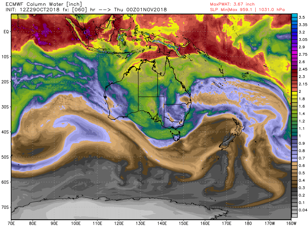
Up above, this is the graph for the Precipitable Water, this is a measure of atmospheric moisture. The general rule is anything in brown is dry air, anything purple is mildly humid air, and anything above green is a humid airmass. If you use the scale on the right hand side, anything above 1.5 inches, which is when the yellow collars begin, its tropical air and very humid, and thats where you see the big rain forecast.
But that doesn’t tell the whole picture, whilst it looks humid, there are certain levels that are drier.
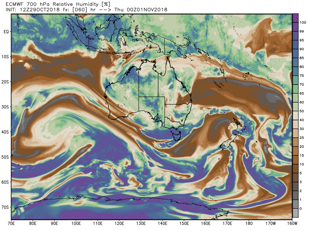
If we look at the 700 mb level, at 10,000 feet, you can see that a lot of the country has humidity at this level at 65% and above, so a humid airmass for sure. At the very least, cloud bands and showers will be developing in this airmass over the next 2 days.
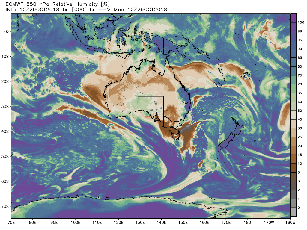
However, look at the 850 mb level, at 5,000 feet, and see you a totally different story, there is more drier air than humid air, and as the rain falls, it gets evaporated and any rainfall becomes light and patchy.
This has been an issue now for many months, and is not unexpected int here times we are in, which is a neutral pattern.
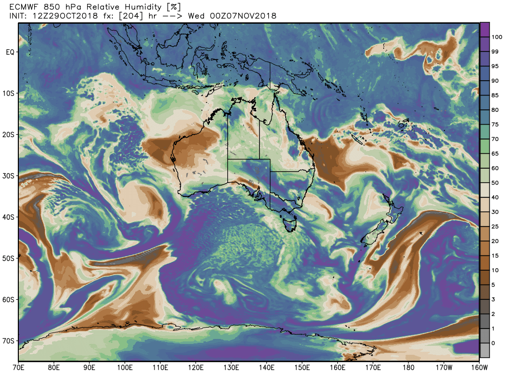
But for the first time this year, models are now seeing very good low level moisture to develop on Cup Day and move into NSW. This should see a big increase in the chances for more solid rainfall.
And the good news is the European model above has moved the drier air into WA, and the very humid air into Eastern Australia, we should then get a chance to see good rainfall next week.
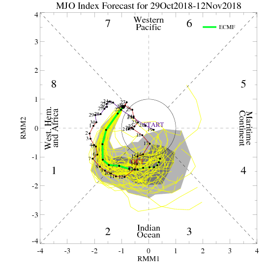
The other major component is the Madden Julian Oscillation, every model now has this swinging strongly into Phase 3 and 4 by the end of next week, these are the La Nina Phases.
In the graphic above, the green line shows the forecast, the black dots represent the next 14 days. Basically this indicates where the tropical convection and lower pressure is strongest along the Equator.
When it comes into Phase 4 and 5, we usually see a big increase in rainfall in the weeks following. So by the 3 rd week in November, I expect a cyclone to be sitting off the NW coast, thats should then feed widespread heavy rain into the country.
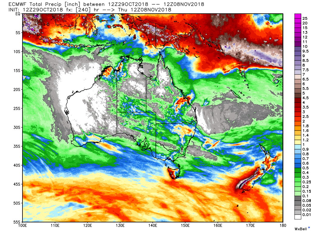
Looking at some forecasts, the European model sees the best rain going South with the first event, and also North with the second event, leaving Southern NSW rather dry.
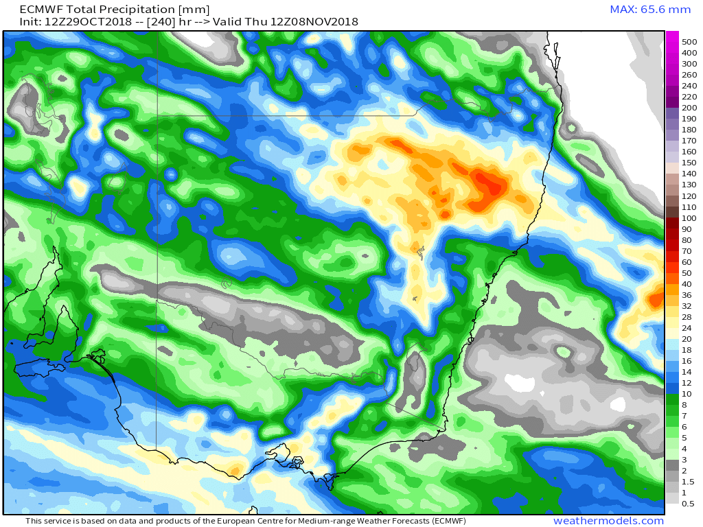
The close up of that forecast still looks like this, its worth noting that the European model is very poor with thunderstorms, it doesn’t see them well, the GFS is a much better model for thundery weather.
However the European is the best for broad scale patterns, and even though it has the rain North, it may adjust that in the next few days and bring that rain further South.
The other model is the Canadian model, its very bullish for rainfall, it doesn’t take the rain North. It has thundery showers on Friday and Saturday, and then further thundery showers late Sunday into Monday, before a big rain event late Tuesday into Wednesday.
This model has shown the most consistency, and hasn’t moved much with its forecast in the last 48 hours. So we might see a blend of these models develop.
For the next period of weather, from Thursday November 1 – November 8th, I expect 15 – 25 mm for Harden and surrounding areas. I do expect again the first lot of on Friday will be thundery, and thus we may see only a few mm about rather than anything major.
Given we are also transitioning into a more active pattern, the forecasts are likely to be changing regularly models are only just realising we are not under El Nino influence, but more the other way around, and a La Nina atmosphere is occurring.
I will have another update on Thursday, before this event kicks off, with the very latest info, see you then.